
Map every acre
Draw your blocks on satellite and the acreage figures itself on save, down to the tenth. Acres or arpents, your pick, per farm.
Made for sugarcane farmers
Draw your blocks on satellite and the acres figure themselves. Tag each one with its variety and its cut. Log the work, log the tons, and print a sheet your crew can actually carry.
It opens on the phone in the truck and on the old computer in the shop. No training, no manual, no middleman.
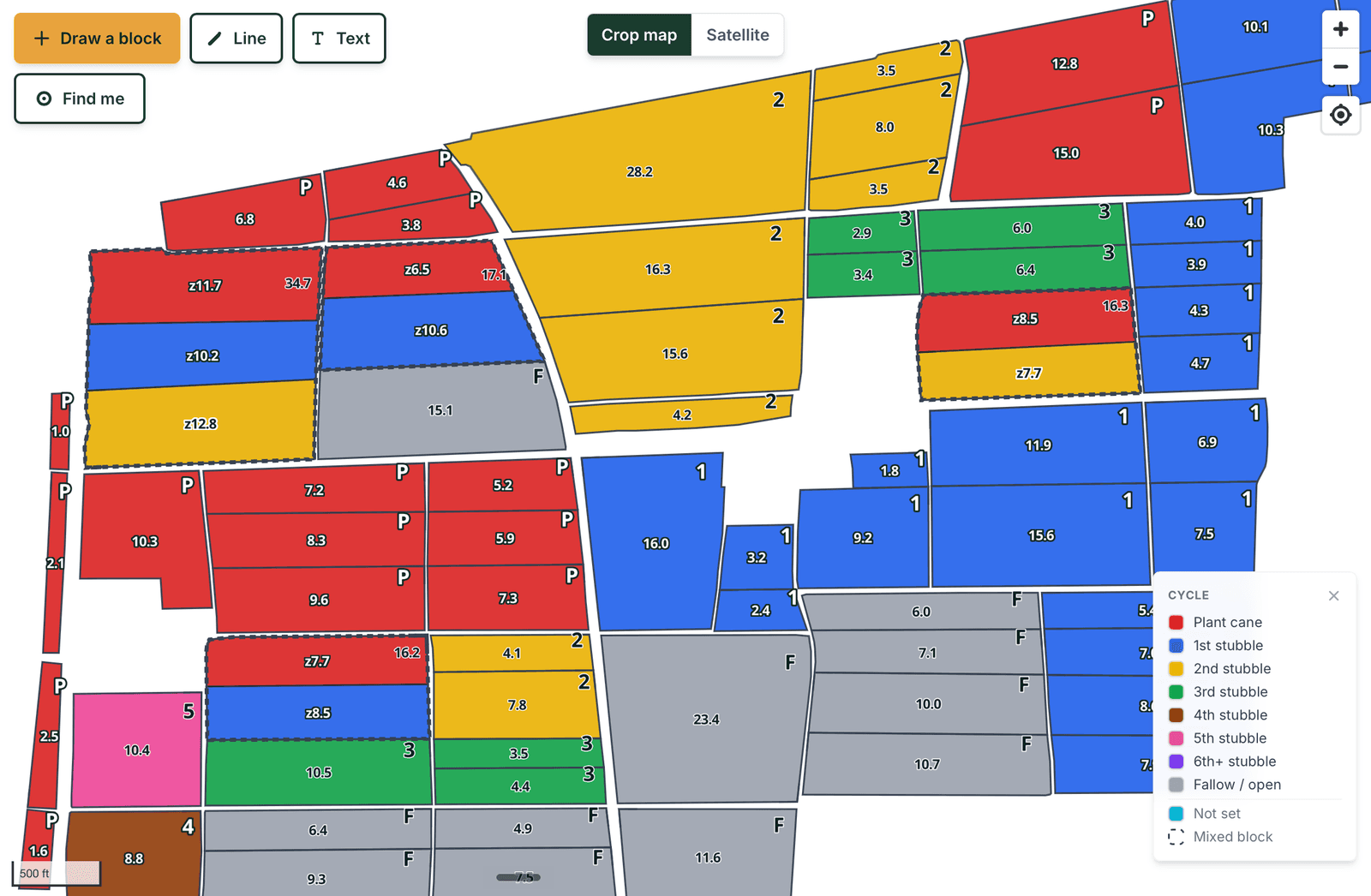
A real crop map. Blocks colored by cut, and the dashed ones carrying more than one variety.
Why Headland
Headland is the one in between, and it is the only one built for cane and nothing else.
The old programs
Built in the 2000s and stuck on one aging PC in the office. Slow, hard to get help with, and one dead hard drive away from losing ten years of records.
The new platforms
Priced for row crop at scale and stuffed with features nobody asked for. You need a call with somebody before you can map a single block.
Headland
Opens on the phone in the truck. Runs on the old PC too. Simple enough to use the day you sign up, and it only does cane.
Built on feedback
We did not guess at what cane growers needed. We asked, then we watched them use it, and we fixed what got in the way. Here is some of what changed.
“This block has two varieties in it.”
Split a block into zones. Each zone keeps its own variety, cut and acres, and prints that way too.
“Logging one field at a time takes all morning.”
Pick every block that got the same work and log it once, with the date and the product.
“I want to see which ground actually made tons.”
Put in the tons off the machine and color the whole farm by tons per acre, for any season you have numbers on.
“We do not call it that.”
Type your own words for cycles and varieties. They color, filter and print exactly like the built-in ones.
“Everybody I know colors their map different.”
Pick your own color for every cycle and variety, and lay a pattern over it when two colors start looking alike.
“The computer in the office cannot run it.”
Lite mode. Same map, same records, no graphics card needed.
“I am not going to go look up the burn category.”
It pulls the LDAF category day for you and files it with the record. Works on old burns too, so an audit is not a research project.
Harvest
Put in the tons off the machine and the map colors itself. Your best ground and your worst ground side by side, for any season you have numbers on.
The legend shows the Louisiana state average next to your range, so you can tell the difference between a block that is weak for your farm and a block that is weak for the state. Split blocks are scored zone by zone, so a strong half never gets buried in a block average.
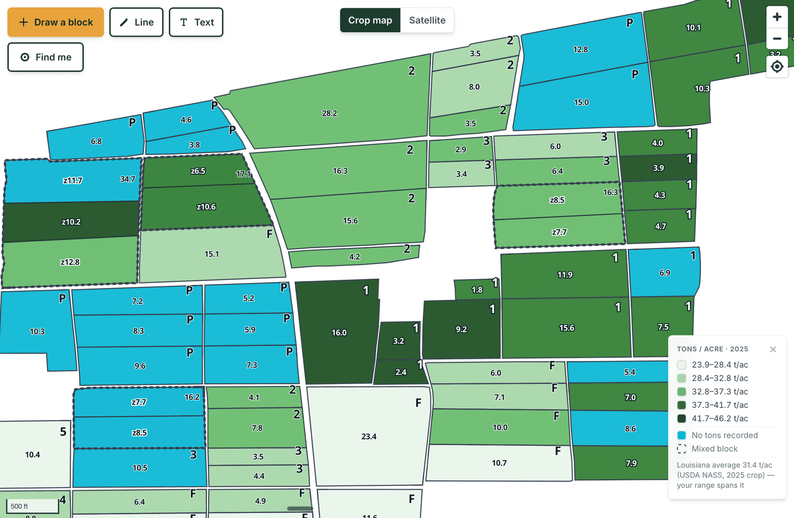
The same farm, colored by tons per acre.
Sharing
Your co-op agronomist needs to see the map. FSA wants acreage. Instead of emailing files back and forth, you hit Share and Headland gives you a six-character code. Read it to them over the phone. Whoever types it in sees everything and changes nothing, and you take it back whenever you want.
The code works once and expires in an hour, so it is good for the conversation you are having and nothing after it. It has no I, L, O or U in it either, because those are the letters that get misheard over the phone. If somebody would rather have a file, export your acreage as a shapefile or KML in one click.
Who can see your farm
You, and anybody you hand a code to. Other growers on Headland cannot see your ground. We do not sell or share your tonnage, your varieties or your maps with anybody, and we never will.
The lock is on the records themselves, not just the screen. There is nothing to poke around and find.
What you get
Draw your blocks on satellite and the acreage figures itself on save, down to the tenth. Acres or arpents, your pick, per farm.
Tag each block with variety, plant date and where it is in the cycle. Plant cane through sixth stubble and past it, or whatever your operation calls it.
Two varieties in one block is normal. Split it into zones and each piece keeps its own variety, cut and acres, on the map and on the sheet.
Log tonnage and harvest dates season after season, then color the map by tons per acre and see your best and worst ground side by side.
Pick every block that got the same spray or the same trip across, and log it once. The weather at the time is recorded with it.
Print a clean crop map with no satellite clutter. Blocks colored by cut, acres and names on every one. Free, and as many as you want.
If the office PC chokes on modern maps, Lite mode gives it the same map and the same records without the graphics.
Catch Johnson grass coming up, drop a pin on it with a photo, and put a to-do on that block. It stays on the list until somebody marks it done.
Export a shapefile or KML out of your old program and load it yourself in a few minutes. The day that PC finally dies, you are already moved.
Pricing
One price covers your whole operation. A 1,000-acre farm is $500 a year. Pay for the year up front and two months are free, which saves $100 against paying month to month.
Printed sheets for the crew cost nothing. There is no setup fee, and the 14-day trial does not ask for a card.
Questions
Headland is field mapping and recordkeeping built only for sugarcane. Draw your blocks on a satellite map, track variety and cut on each one, log harvests and sprays, and print a clean field sheet for the crew. All in one place you can open from the truck.
Fifty cents an acre per year. A 1,000-acre farm is $500 a year, 4,000 acres is $2,000. Pay for the year up front and two months are free. No setup fee, printed sheets for your crew are included, and there is a 14-day free trial with no card.
Yes. Split the block into zones and draw them the way they sit in the field. Each zone carries its own variety, its own cut and its own acreage, and it prints that way on the crew sheet. A block with more than one thing in it shows a dashed outline so you can pick it out from across the farm.
Yes. Put in the tons off the machine and color the map by tons per acre for any season you have numbers on. The legend shows the Louisiana state average alongside your range, so you can tell whether a weak block is weak for your farm or weak for the state.
Yes, and you do not have to email anything. Hit Share and Headland gives you a six-character code. Read it to them over the phone and whoever types it in can see your farm and change nothing. The code works once and expires in an hour, so it is good for the conversation you are having and nothing after it. Take their access back any time. If somebody needs a file instead, export your acreage as a shapefile or KML.
Yes. If the machine is too old for modern mapping, Headland switches itself to Lite mode: the same map and the same records, drawn without the graphics that choke an old PC. You do not have to do anything.
Yes, and that is the point. The variety lists, the cycle from plant cane through stubble, the field operations, the burn records, all of it is built around how cane actually gets grown instead of bent to fit from a corn and soybean tool. It was built in the Louisiana cane belt with growers there, and it works anywhere cane is grown. If you farm cane, it will fit how you farm.
Yes, and you do it yourself in a few minutes. If your old desktop software exports a shapefile or KML, upload it and match up your columns. Nothing gets retyped. If you get stuck on it, call and we will walk you through it.
No. You run the records and your crew works off printed sheets, which are free and unlimited. You pay per acre, not per person.
Yes. Say you catch Johnson grass coming up in a block. Drop a pin right where it is, snap a photo, and put a to-do on that block to spray it. Both are on the map back at the office before you are out of the field, and the to-do stays on the list until somebody marks it done. Nothing to install.
You, and anybody you hand a code to. Other growers on Headland cannot see your ground, and we do not sell or share your tonnage, varieties or maps with anybody. The lock is on the records themselves, not just the screen.
A third-generation Assumption Parish cane family and the son-in-law who builds the software. No investors and no call center. When you email, you reach the people who farm with it and the person who builds it.
Free for 14 days and no card to start. Built by a cane family, for cane farmers, wherever you grow it.
Start free. No card.